The Meso-Scale Mapping Project
Background
In 2014 I was hired by the government of Ecuador to work as a member of the Prometeo Project. For a time spanning more than 6 months I was a mentor for a team of young geologists in Ecuador's Geological Survey, INIGEMM. Working in Quito, in the jungle, in the southern mountains and desert, and later remotely from my home in the U.S. I helped their effort to remap the geology of the country with the aim of assessing the mineral resources and identifying and mitigating natural and environmental hazards.
While there, I began two new projects. First, I designed and built and tested an inexpensive and compact magnetometer for field use by geologic teams to add important data to their maps. The prototype of this instrument was donated to the institute there. Second, I worked on the problem of integrating, assimilating, and understanding multiple geologic and geophysical map data sets through principles of data mining and machine learning. These projects combined with my past work on various sensors provide new inspiration for what follows.
Using this momentum, I decided to create a set mapping tools at high resolution and areal coverage for a neglected middle or “meso” scale, that is something between traditional satellite or aerial remote sensing and that done by geologists on foot.
About a decade ago a colleague (Professor Ron Bruhn, University of Utah) and I tried to launch a project of close-in photographic imaging of small landslides in mountainous areas for purposes of hazard evaluation and monitoring (link to example). In another related effort at about the same time, I had worked with another colleague (Professor Chris Barton, Wright State University) to design and build a laser range-finding system to monitor minute changes in beach topography due to coastal erosion processes. These projects were not advanced nor funded in part due to inadequate available technology.
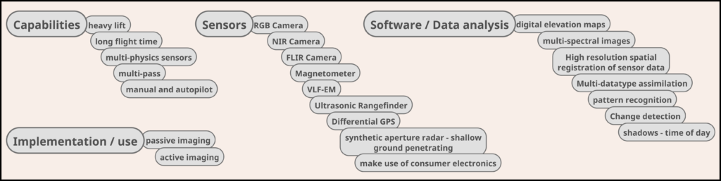
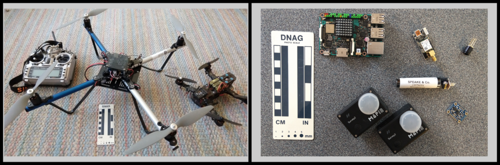
This has all changed. In just the last few years we have seen rapid growth in several key areas: (1) availability of new compact and inexpensive sensor technology, much of it generated through consumer products, (2) the availability of powerful embedded computers and the “internet of things,” (3) advances and availability of remote autonomous vehicles such as quad-copter drones, surface robots, and watercraft, and (4) the development and accessibility of open source data mining and machine learning methods.
I see an opportunity, by integration of these various methods and hardware combined with education, to empower people by developing and putting new technology in the hands of those who need it to solve their problems. Potential applications for these tools include: landmine and UXO detection, landslides, beach morphology change, geomorphology and erosion, plant stress in agriculture, climate change, infrastructure and hazards, archaeology, and earthquake damage.